 I asked the other day "what is underneath Robertson?". I gave the large scale answer, by showing medium distance photos of the district, showing both the plateau surrounding the Upper Kangaroo Valley, and Bell's Hill, rising above the plateau.
Here is what Bell's Hill looks like, from Robertson itself. This image was taken beside the Cheese Factory. You can clearly see the rich red basalt soil, having recently been ploughed, probably for next season's potato crop.
In my post of the other day, about the strata of stone under Robertson, I suggested one could draw a line across under Bell's Hill, at the level of the sandstone plateau - and deduce that the sandstone was continuous, right across, under Bell's Hill, and indeed the rest of Robertson. Today, I take the specific, or close up, approach.
If you drive to the bottom of Fountaindale Road (from Ranelagh House), you start on deep red basalt soil - the kind visible in the Bells Hill photo above. You are in a grove of rainforest trees.
 As you start to flatten out onto the main area of farming land, you have dropped off the red soil, onto deep black soil. This soil is formed as the strata known as the Wianamatta Shale breaks down into soil - fine black soil.
This deep black soil makes good grazing country, and is mostly used these days for beef cattle production. Originally it was home to tall Eucalypt forest, and rainforest remnants.

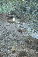
At the bottom end of Fountaindale Road, the road runs into the tall Eucalypt forest, and the soil changes to a sandy mixture. The depth of soil here is clearly visible in this creek side. It is probably about 30 metres deep.
This soil is a combination of black soil, washed down the hill, and the underlying sandy soils, derived from the sandstone base.
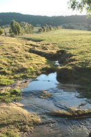
 When you look closely at the bottom of the creek (it is a typical shallow stream, only a few inches deep) there is a flat base of exposed rock - a classic sandstone stream bed. And yet, this sandstone rock base is surrounded by the rich grazing country you see in the photos above and below.
Sandstone does not give you this rich farming country. You are looking at the lower strata of rock - the sandstone base. That underpins the more fertile black soil derived from the black shale, which is a separate deposit, in geological terms.
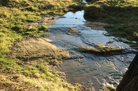
 Out in the paddock, there is a small stream, just starting to erode through a much shallower layer of black soil, down to a sandstone rock shelf. Here the topsoil layer is less than 60cm (2 feet) thick. But the tell-tale flat shelf of sandstone rock is clearly visible.
The depth of the black soil is quite variable, obviously, if you compare this photo with the previous photos taken in the adjacent deep creekbed, just 50 metres away.
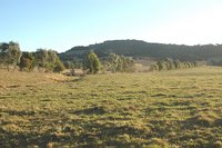
 If you walk away from the deep creek and look up the hill, you see rolling paddocks, heading gradually up towards the mounded shape of Bell's Hill.
This image shows the complete picture - the exposed sandstone base, the black soil in the pasture land above, running back up the hill, to the slopes of Bell's Hill, less than 1 Km away.
So here it is: the sandstone strata, running directly under the basalt cap of Bell's Hill.
If you could get an equivalent picture elsewhere, under Robertson, it would be the same story. A continuous shelf of sandstone rock, underneath the basalt caps, and the rich red soil. And in between them, a layer of the Wianamatta Shale, which produces the black soil which is mostly is used for grazing country around Robertson.
The same pattern is repeated as you drive south, down Belmore Falls Road, or going north, you drive down Kangaloon Road, and along Kirkland Road, in East Kangaloon. In each case, you run into sandstone scrub country, as you reach the level of the sandstone plateau (at Belmore Falls, and the Tourist Road).
So, rainforest (on the red basalt soil) gives way to tall Eucalypts or cleared grazing country (on the deep black soil), which in turn, give way to Sandstone-based Eucalypt and scrub country. It is these latter pieces of habitat which are mostly now preserved as National Parks, or the SCA "Special Area" along Tourist Road. The red and black soil areas have long ago been appropriated for farming country, unless they are too steep to farm - that fact explains the patches of remnant rainforest around Robertson - mostly on rocky hilltops, and in creek gullies.
So, the sandstone underpins the Nature of Robertson, and dominates the surrounding countryside.

No comments:
Post a Comment