
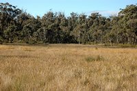
Butler's Swamp -
endangered, but supposedly protected
under Federal and NSW laws
 I was fuming when I got to the answers relating to several questions which I had drafted.
"The “depth to water table” column in Table 5.1 (P. 29) at sites # 2, #3, #4, #5, #8, #9, Stockyard Swamp and site #12 (East Kangaloon) all report water table depths of less than 20 metres. That puts the pre-pumping water table at all those sites within the reported range of Eucalyptus roots (Scoping Study, 5.2.3 p 24). Consequently, to commence pumping, and hence to knowingly draw-down water levels, in any of those areas, would threaten the survival of the key species within this environment. Many of these areas support Endangered Ecological Communities, protected under NSW and Federal legislation.
To draw-down the water table in any of these areas, with a time frame of up to 10 years, would be unconscionable.
Their answer was partially correct, but entirely misleading:-
"The Scoping Study was not an assertion that Eucalypts in this area have tap roots to 20m in solid sandstone. The scoping study suggested that this was a possibility (based on rooting depths in unconsolidated formations elsewhere) and that this should be looked at. It is generally agreed that these species are principally sustained by rainfall and the groundwater component is much less important. Further information will be available in the upcoming SMEC study."
Who is talking about "tap roots"? Feeder roots are the key to plant survival. Tap roots are critical at seedling stage, and help physically stabilise the plant in the soil. But feeder roots do the work for which they are named. They can easily reach down to the water table, especially in sandstone, where the bedrock is so heavily cracked.
Also, may I ask "It is generally agreed" - by whom? Those words are meaningless - an argument to an unstated, unwritten authority. It is merely an assertion, without any evidence.
*****
In an earlier question I had asked:
The “supply” of water in the aquifer might be renewable, over up to seven years (Pp 33, & 40), but as water is integral to the environment, and as a number of ecosystems are acknowledged as being ground-water dependent, it is surely not “sustainable” to draw down water from the root zone of plants, for up to ten years (a 3 year pumping cycle, plus up to 7 years recovery to pre-pumping levels). This would surely threaten the survival of plants and, consequently other fauna types, within large portions of the study area.
The SCA answer is a nonsense:
Also water is NOT being drawn from the root zone of plants – the average depth to water table is around 15m and is in the sandstone bedrock well below the rooting depth of most species.
Butler's Swamp - woodland.
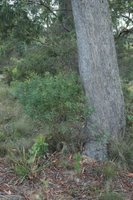 There is a "Threatened Species" of Persoonia here, growing beside a huge Eucalypt. The water table here is measured at 4 or 5 metres.
Where are the roots of this Eucalypt going?
 There is a "Threatened Species" of Persoonia here, growing beside a huge Eucalypt. The water table here is measured at 4 or 5 metres.
Where are the roots of this Eucalypt going?
To average the depth of the water table across the borefield is a statistical nonsense, when we are talking about survival of trees in specific habitats. Their own papers report water tables as shallow as 4-5 metres, in some testing bores. You cannot say to the plants living there - "Sorry, plant - the average depth is supposed to be 15 metres - you should not be drinking this nice shallow groundwater". Plants live where they live. It is called a micro-environment.
For example, the 2 photographed areas have totally different habitats. They are less than 100 metres apart. You simply cannot average them - for example, they have totally different plant forms, with different soil conditions, different everything.
Studies like this have to deal with reality, not statistical nonsenses, such as water table depth averages over a huge area of a borefield.
Lies, damned lies and statistics.
Also, their reply that "water is NOT being drawn from the root zones of plants" is absolutely contradicted by the studies themselves.
In one part of the report, they comment on microscopic crustaceans found in the aquifer, which feed on tree roots. OK - which tree roots, if there are no plants with their roots in the aquifer?
In another part of the studies, they acknowledge some loss of water from the aquifer, by transpiration. How else does that occur except from plants having their roots in the aquifer?
False statement after false statement. That is what the SCA produces.
*****
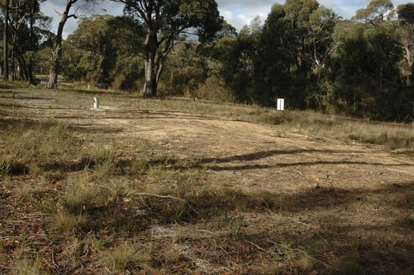
DO YOU TRUST THEM?

THIS IS THE SCA's IDEA OF REHABILITATION.
*****
2 comments:
Denis, this drawing down of aquifers - has SCA done this elsewhere and, if so, with what results? Desertification?
No. The SCA has not gone down this path before.
Other places have. Perth has nearly dried out its aquifer, which is on sand - so it had different geology.
Not aware of other major cities doing this. Of course, the Great Artesian Basin is being dried out at a terrible rate. Shallow Bores are drying up. But it also has different geology.
Our area is dominated by springs in the tops of the local hills (on basalt, over the sandstone). That is what the main debate is about. Will draining the lower part of the aquifer, dry up the hilltop springs? If so, it will also dry up the mountain creeks.
We don't know (yet) - and they say it will all be OK.
Can we trust them? Do they even know?
Post a Comment