
 The SCA keeps repeating the mantra that the basalt hills have springs at the lower levels, where the basalt caps meet the underlying (impermeable) shale layer. This is yet another of the SCA's half truths.
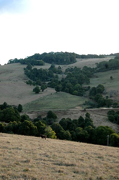
There are indeed springs at that level, but they are not the important springs. They are not the ones which create the mountain streams which dominate the Robertson environment. It is self-evident that they are not. Take a look.
The line of trees - Sassafras and Blackwood, mostly - typical Robertson Rainforest trees, run down that hillside. They are following a stream.
 A what? A stream - permanent water. How does it get there? From a spring close to the top of the mountain.
 See how the trees turns at nearly a right angle, most of the way up the hillside. That is not just because of a property boundary - it is because they are following a creek line, running from one of several springs at the top of the hill.
This hill is entirely made of a basalt cap. The "basalt-shale interface" is hundreds of feet below this level, on the black soil level, where the land flattens out below the hills. This spring is not at the junction point between the basalt and the shale. It is way, way above it.
 Halfway down the hill, there is a dam - the first dam in a series.
According to the SCA's simplistic geological model, this mountain stream ought not exist.
They refuse to acknowledge that there is a problem, because they say that all water runs downhill. That is why they keep talking about springs at the junction between the basalt and the shale. That is too simplistic.
 I have seen springs on top of local hills, and many hills have springs very close to the top, as in this one.
Lower down the hill there is a second dam.
And then the stream runs out onto the much lower level of flat dairy-farming land a the bottom of the hillside. At that point it becomes the Nepean River - one of the legendary rivers of the Sydney Basin - the progenitor of the mighty Hawksbury River. It all starts here.
 These photos were all taken from the one point, two thirds of the way up the hill from East Kangaloon. This is very close to being the highest point in the Nepean River catchment. The very start of the chain of waters which supply Sydney. The first shots were looking up to the ridge opposite. The last shot is looking down over the distant Nepean River catchment. Ground water responds to pressure. It is entirely possible that a spring on top of a mountain is forced upwards by the pressure of the entire body of water in the hillside, forcing water up through a mini fault line, or fracture in the rocks. How far below the point of the spring does this pressure find its way back up the hill? Could it come from the sandstone aquifer? The SCA says no. Time alone will tell.
According to the SCA theory, the springs start another kilometre (distance) away, further down the slope. This is a graphic illustration of the nonsense they want us to believe.
*****
If this permanent creek dries up, after the pumping starts - we will know the truth of their great lie, (or their incompetence).
*****
We are engaged in a great gamble - for the future of the natural environment in Robertson. I am not prepared to risk the future survival of entire ecosystems. They are. That's the basic difference in our approaches to this issue.
No comments:
Post a Comment