Christmas Bells

Christmas Bells
Christmas Bells - Blandfordia nobilis

Tuesday, July 18, 2006

The Nature of Children's Graves - bulletin 1

The Robertson Cemetery is found at the end of Missingham Parade - the road on which I live.

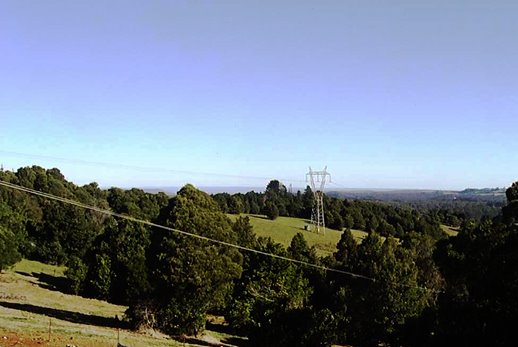
View south, over Kangaroo Valley

It is in a wonderful place. It has fantastic views out over Kangaroo Valley (see my photo at left). It is exposed to the south, so it is often windy, (but only on windy days!)

It also has great views across to the ridge where Pearson's Lane runs. That view is captured well on the photo gallery of the Robertson Chamber of Commerce.

A child's grave, with steel cage and headplate
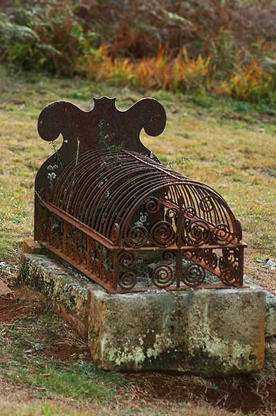
I am fascinated with the children's graves which may be found here. All old country town graveyards have many children's graves - a fact which all modern parents of young children ought realise, when debating the merits or demerits of vaccination.

In the "bad old days" young children died routinely of diphtheria, whooping cough and measles, as well as other diseases which we now readily control with antibiotics. But the communicable viral diseases were the real child killers. They still are, potentially.

All expectant parents ought visit a country graveyard, I think.


Some diseases of childhood, namely: Diphtheria, Tetanus and Whooping Cough are covered by the "Triple Antigen" vaccination for children. Hepatitus B, and oral (Sabin) Polio vaccinations are being encouraged to be given to all children. Pre-pubescent girls are routinely given the Rubella vaccination, to prevent the terribly damaging effects on the foetus, should a woman contract Rubella during pregnancy.

Anyway, grave stones seldom give the cause of death - it is just the fact of the death which is left with us, because of the grave.

Detail of Iron work on "cage"

This little grave intrigues me greatly.

The "cage" over the grave is in good condition, but the steel plate which acts as the "head stone" is heavily rusted, and sadly, no inscription is visible now.

The ironwork in the "cage" is very high quality work, and has lasted very well. It is rusted, superficially, but in Robertson Cemetery, that looks completely natural. To me the whole grave looks like a work of love - for the little child beneath.


The rear view of the steel"headstone"

The steel plate which acts as the "head stone" is heavily rusted, and sadly, no inscription is visible now. But what is the shape of the "cutout" symbolising?

Is it meant to be a guardian angel?

To me, it actually resembles a bat, but that is such an unlikely image. I hope that no-one regards my interpretation as disrespectful - no such thought is intended.

I would love to know the history of this grave.
*****
Tomorrow, I shall show you another Robertson grave - my personal favourite.

Sunday, July 16, 2006

The Nature of Eagle Flight

A moderate, but steady wind was blowing from the south-west at my place, today. As I am near the top of a ridge, with a valley facing south-west, below me, this means that the wind was running straight up my valley, creating wonderful "uplift", just above my house. This is a perfect situation for the Little Eagle (Hieraaetus morphnoides). This bird did a number of "passes" up and down the valley, today.

CIRCLING BACK UP THE VALLEY

The bird would circle around to gain height, as it came back up the valley (photo 1).


Clearly it was hunting, for it was not just "making lazy circles in the sky" (to quote from the song in "Oklahoma"). Once the bird has got high enough up the valley, to get the desired "uplift" from the ridge below, ti would "freeze" (hover). But although it was perfectly stationery, it was working very hard, adjusting its wings and tail constantly, in order to keep its head absolutely still. On several occasions, it would hold the one position (relative to the ground) for a minute or more, at a time, before moving off a little further, then holding position again - but it was working hard to achieve this "fixed" position.

See the various photos below, to observe the different wing and tail "settings" the bird was using.

PERFECT WINGTIP CONTROL

Medium-large birds of prey, such as this Little Eagle rely on using "uplifts" to achieve their hovering effect. Hence today's demonstration, just over the back of my deck.

This shows perfect balance of uplift against gravity, with wingtip control.

Having circled back up from the bottom of the valley, when it found a position high enough in the valley to get the "uplift" again, it then "froze" in the sky, looking for prey. Rabbits and lizards are its main food, but this species has been recorded taking birds, and insects. Apparently it has a preference for young rabbits (which would suit its size).


FULLY EXTENDED WINGS AND TAIL

On several occasions it had to spread its wings and tail to the fullest possible extent, in order to "hold position" - but it was not flapping. It was still stationary in the sky.

Presumably this is in response to a momentary drop in the wind strength, requiring the bird to maximimise its wind resistance (for just a second or two), to hold its position, before the wind picked up again.

Note the "concentration" evident from the positon of its head. This bird was actively hunting. It is scanning the ground below, for a careless rabbit, or possibly a bush rat.


HALF-SPREAD WINGS AND TAIL

The bird was constantly adjusting the settings of its wings and its tail, to keep its head stationary. It is not moving across the sky - it was stationary, relative to the ground.


MOVING TO THE LEFT - TO A NEW POSITION

Then it would move to a new position, a little further away, across the valley, and repeat the process.

Having moved perhaps as little as 50 metres, it would resume the previous hovering stance, with just wingtip control being used to keep its position in the sky.

What a wonderful demonstration of flight control. My thanks to the Little Eagle, and the wind conditions which made this display possible.


It is great to be alive - to appreciate these special Nature of Robertson moments.

In the great Aussie vernacular: "Ya wouldn't be dead for quids".


The Nature of a clear day


I am posting a "clear day" view, in response to Miss Eagle's comment from yesterday.

Foggy days are not good for Eagles - they get lost in the clouds, or like me, sit at home, waiting till they can safely spread their wings again, when they can see where they are going.

Today is half-clear, at least not raining. But I am posting a photo from the end of May 2004. It demonstrates my comment that winter days give the clearest views. You get less haze from the Eucalypt forests down below, in the Shoalhaven Valley - that blue haze which is so familiar to us Aussies. It is caused by the volatile oils given off by the Eucalypt trees. You get less of that haze in winter.


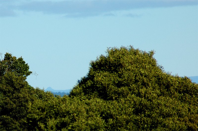
I am also posting a "glimpse" of Pigeonhouse Mountain, (you have to peer a bit, bit it is in the lower left side of the gap between the two tall trees - it appears as the very tip of a conical mountain). I can just see Pigeonhouse, on one of those clear, crisp winter days, from my new deck. This is taken using the full power of my long lens on my camera, with everything else cropped out. This photo was taken 2 weeks ago - on one of those clear winter days.

Pigeonhouse Mountain is 67 Kms from Robertson, according to the maps, so that's not a bad range of view. It stands out, very distinctively, above the coastal ranges, behind Ulladulla, well south of Nowra.

It is famous for having been one of the first landmarks on the Eastern Australian coastline, named by Captain Cook, as he sailed towards his landing point, at Botany Bay. I believe he may have named Mt Dromedary before he named this point. So, in terms of European history of Australia, it is perhaps the second earliest name, on the east coast.

Saturday, July 15, 2006

The Nature of a grey day

After weeks, if not months, of agonising about the future of the Kangaloon Aquifer, and then discovering the horrors being inflicted on the rivers downstream from here, by Longwall Mining, today the Nature of Robertson has stepped in, and said: enough of this madness. Today is a Grey Day. Take the day off.

There is nothing which we paltry humans can do about it - it's grey, grey, grey.

And, in its own way, it is beautiful.

The green relief is provided by the lovely Sassafras trees (Doryphora sassafras).

This is the view from the rear deck of my house - thanks to David Cupitt for its construction.

Friday, July 14, 2006

The environmental threat of Longwall Mining

"Longwall mining as a key threatening process"

Below my "opinion" piece here, I have re-published the text of a Fact Sheet prepared by the Dept of Environment and Conservation (NSW). 26 July 2005. Under the Copyright provisions cited by their website, my use of this document
, for non-commercial purposes, is legitimate. The DEC authorship is fully acknowledged, and the text of the document has not been altered in any way, by me.

It fully sets out the environmental damage inflicted by the process of Longwall Mining. There is an associated "Declaration" (see link at below) which is the formal document.
Alteration of habitat following subsidence due to longwall mining - key threatening process declaration
All very well and good.
*****

What has happened since this declaration was published? Business as usual, in the mining industry, that's what.

The Dept of Environment and Conservation has done the right thing, but the decision makers in the Mines Department and whoever else decides these things are still going flat out to crack the bedrock in the Catchment - despite the formal declaration of this process as being an "Key Threatening Process" to Endangered Ecological Communities.
Hence my reference to the DEC as a "Toothless Tiger".

Don't get me wrong, I support what they have written. But have they really exercised their full powers under the Threatened Species Act to actually prevent damage being incurred?
Or have they just issued a "determination" - and left it at that?
*****

These are just some of the powers available under that Act.

Interim Protection order
The Minister for the Environment may make an interim protection order for a period of up to two years over an area of land that has natural, scientific or cultural significance. The Minister may also make an interim protection order on land where the DEC Director-General intends to exercise functions relating to threatened species, critical habitat, or declared critical habitat under the NP&W or TSC Acts.

Stop Work Order
The Director-General of DEC may make a stop work order for a period of 40 days if an action is being, or is about to be carried out that would harm a threatened species, population or ecological community or it’s habitat. These orders can be renewed for 40-day periods as required.

*****
I haven't heard of any such powers being used, to stop Longwall Mining by BHP Billiton or their subsidiaries. Have you?

Denis Wilson
*********************************************************************
The following it the text of the DEC Fact Sheet
*********************************************************************

Alteration of habitat following subsidence due to longwall mining as a key threatening process - fact sheet

'Alteration of habitat following subsidence due to longwall mining' has been listed by the NSW Scientific Committee as a key threatening process under the Threatened Species Conservation Act 1995.

What is longwall mining and how does it cause subsidence?

Longwall mining is an underground coal mining technique which involves removing a portion of an underground coal seam. Longwall mining can cause the land above the mined-out coal seam to destabilise and collapse – this is known as subsidence.

The extent of subsidence is influenced by various factors, including the width and depth of the longwall mine, topography, the type of overlying rock layers, the design of the mine and the location of the mine. These factors vary from site to site, so the amount of subsidence - and its subsequent impacts - also varies.

What is alteration of habitat?

The specific area or environment in which a plant or animal lives is called its habitat. A habitat provides all the basic requirements for survival. Alteration of habitat refers to a change in the structure or function of habitat, making it potentially unsuitable for the organism to live in. Subsidence due to longwall mining has been recognised as causing habitat alteration. Species and ecological communities that depend on aquatic and semi-aquatic habitats are particularly susceptible to the impacts of subsidence.

Subsidence due to longwall mining can cause deformation of ground surfaces as well as cracking of valley floors and creeklines. This can affect natural water flow regimes and water quality, depending on such factors as the width of the crack, riverbed steepness, the riverbed material and the presence of organic matter. Subsidence can also destabilise cliff faces.

In turn, these impacts can lead to the alteration of species habitats and changes to the ecological function of communities. Effects can be temporary or long-term. When water flows are altered, there can be permanent effects on the functioning of ecosystems in localised areas, which may be exacerbated in drought conditions.

Why list 'alteration of habitat following subsidence due to longwall mining' as a key threatening process?

The NSW Scientific Committee in its final determination concluded that alteration of habitat following subsidence due to longwall mining:

  • adversely affects two or more threatened species, populations or ecological communities, or
  • could cause species, populations or ecological communities that are not threatened to become threatened.

What species, populations and ecological communities are particularly affected?

Threatened species and ecological communities are known to occur in areas affected by subsidence due to longwall mining, and their habitats are likely to be altered by subsidence and mining-associated activities. Species include the following:

  • Blue Mountains water skink
  • giant dragonfly
  • broad-headed snake
  • Epacris hamiltonii
  • eastern pygmy possum
  • giant burrowing frog
  • stuttering frog
  • large-footed myotis.

Endangered ecological communities identified in the listing include the following:
  • Genowlan Point Allocasuarina nana heathland
  • O'Hares Creek shale forest
  • shale/sandstone transition forest
  • Newnes Plateau shrub swamp in the Sydney Basin Bioregion.

Subsidence associated with longwall mining can significantly affect the water balance of upland or hanging swamps. Even though subsidence may be detected within a few months of a mining operation, related changes in vegetation can occur over a longer time period.

Mining subsidence can also destabilise slopes and escarpments. Changes to cliff line topography can change the availability of roosting sites for bats and nest sites for cliff-nesting birds.

What are the implications of the listing?

The Department of Environment and Conservation is required to develop strategies for mitigating or managing the adverse effects of this threatening process on our native wildlife. The mining industry and wider community will be invited to contribute to the development of these strategies.

Strategies may include:

  • reviewing existing policies, regulatory and non-regulatory regimes
  • preparation of impact assessment guidelines.

A number of actions are currently underway to address the environmental impacts caused by subsidence. The actions include the development of subsidence management plans as required under the Mining Act 1992 (administered by the Department of Primary Industries). DEC is on the inter-agency committee that reviews these plans. The effectiveness of these actions will be taken into account when DEC is considering the need for a threat abatement plan.

What does the listing mean for the mining industry?

This listing does not change the current laws regulating longwall mining activities. However, the listing will lead to increased responsibility for - and consideration of - the biodiversity impacts of subsidence caused by longwall mining.

Longwall mining activities will continue to be regulated under the Mining Act 1992. The environmental regulation of the industry is shared with DEC, the Department of Lands, and the Department of Infrastructure, Planning and Natural Resources.

More information


Copyright Department of Environment & Conservation (NSW) - Disclaimer - Privacy - Help
Last amended: 26 July 2005.

Thursday, July 13, 2006

The Nature of Longwall Mining

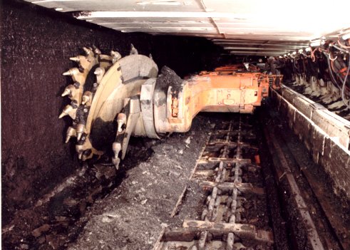
Photo: Coal Leader
"Longwall mining" has been allowed to take place underneath the Illawarra Plateau - close to, and in some places under, the rivers which supply Sydney's water.

Longwall mining is a form of underground coal mining which uses a massive machine called a longwall. The longwall equipment consists of a number of hydraulic jacks, called chocks, roof
supports or shields, which are placed in a long line up to 400m in length in order to support the roof.
Diagram of Longwall Mining
BHP.
Rivers SOS website An individual chock can extend to a maximum cutting height of up to 5m. The coal is cut by a rotating drum with bits called a shearer that moves along the length of the face in front of the chocks, disintegrating the coal. The coal is then removed from the coal face by a moving chain or AFC (articulated face conveyor) (also called armoured face conveyor) to the main gate. Here it is loaded onto a conveyor belt and transported to the surface.
As the
shearer removes the coal, the chocks move forward into the newly
created cavity. As mining progresses and the entire longwall progresses through the seam, the cavity behind the longwall, known as the goaf, increases. This goaf collapses under the weight of the overlying strata."
Text from Wikipedia

Sometimes longwall mining is called destructive or environmentally unsafe because it causes the land above the mined-out panel to sink. This can damage underground water tables, structures at the surface, and can cause erosion of the soil.wisegeek.com


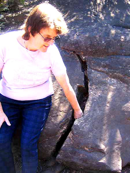
As the coal is removed, and the hydraulic props are removed, the stone strata above the cavity collapse down to fill the cavity. This collapsing produces subsidence all the way up to the surface layers, resulting in cracked rocks.


Cracked rocks in river bank

Contamination of Cataract River
Photos - from Rivers SOS

When the rock strata are cracked, it can allow toxic gases to escape through the rocks, and allow water from creeks above to flow down into the mined areas, (drying up the rivers, of course) and allowing that water to become contaminated with minerals. That contaminated water may well escape back to the surface, bringing the dissolved mineral contaminants into the river systems.

Such contamination is now occurring in the lower sections of the rivers in the Sydney Catchment system.
*****
Contamination of Cataract River
Photo 2 - from Rivers SOS

Unanswered questions:

What notice is the SCA taking of the environment of the rivers?

What is the point of trying to transfer water from the Shoalhaven, if it just gets wasted down cracks into BHP Billiton's mines? Surely that is wasteful.

Why should the Kangaloon Aquifer's pure water be allowed to be wasted and/or contaminated, once it flows downstream?

How does any of this fit with the NSW Government's Advertising campaign on water running on TV at present?

Wednesday, July 12, 2006

The Nature of SCA's incompetence

The Sydney Catchment Authority is incompetent.

It has completely failed to protect the integrity of the water catchment on the Illawarra Plateau, which is responsible for roughtly 20% of Sydney's water source.

The reason is that it has allowed the catchment to be undermined (quite literally), by the coal miners, and they have cracked the bed rock to the local streams.

That has allowed large quantities of water to leak from the stream beds into the mined areas below.

It has also allowed contamination of the remaining waters in the streams, with methane gas, and with mineral contamination.

"Burning gas" Photo: Daily Telegraph 9/7/97


Photo sourced from: http://groups.msn.com/nepeanactiongroup/shoebox.msnw?Page=2
*****

According to the website of the "Nepean Action Group": -
"In 1994 the Bargo river bed cracked.
In 1996 the Cataract river bed cracked and the water disappeared, methane/ethane gas escaped and iron oxide bacterial pollution started.
In 2000, Jutts Crossing on the Georges River at Appin cracked and the water in the rock pools disappeared. In 2001, further up the Georges river cracked and rock falls were reported.
In 2001 the Douglas Park bridge moved as a result of the mining.
In 2001 the Broughton Pass Dam sustained cracking.
In 2002 Marhnyes Hole in the Georges River cracked and water disappeared.

In the mid 90's the Cataract River flow totally disappeared into the cracking in the river bed. Methane and ethane gasses were expelled from the ground measuring up to 20 litres per secondin some areas.

Sydney Water is currently releasing 2.5 million litres a day from Broughton Pass Weir into the Cataract to provide some environmental flow, as the cracking is still allowing most of this water to escape into the ground and mine below. Also BHP are using another 2 million litres a day to dilute pumpings from the other mines into the Georges River. That's 4.5 million litres a day!!!

So now eight years later the water is still disappearing into the subsidence, just as gas is still escaping through the cracks, the fish are gone, the pools are sometimes still red with iron oxide matts and the rock falls continue. The flow into the Nepean from the lower Cataract is still polluted. There are still problems in the Georges, Bargo and other NSW
rivers. Tonnes of salts are being pumped into the rivers from the polluted mines."
Quoted from the Nepean Action Group website


Bargo River - before and after mining cracked the river bed - (1970-75) and 2005)


The Rivers SOS website has a "mine of information" about the river damage, and the whole disaster of allowing "Long Wall Mining" under these rivers. Have a look at the 4 pages of photographs in their "Gallery" pages (use the drop down menu).

I shall write more about the details of "Long Wall Mining", and why it is so damaging.