Christmas Bells

Christmas Bells
Christmas Bells - Blandfordia nobilis

Thursday, January 31, 2013

Wingecarribee Shire CSG and Longwall Mining Free

Clr Larry Whipper, Deputy Mayor of Wingecarribee Shire sent me these two images today.
Sign outside Wingecarribee Shire Chambers
Moss Vale, NSW

One of the signs at entrance way to Shire
These signs are on Highways on edges of Shire.
Well done to Wingecarribee Shire Councillors - all of them. 

Wednesday, January 30, 2013

Carrington Falls running properly again

The people of Robertson are very pleased to see the rivers and creeks running again, and to hear the Frogs croaking and the Crickets and birds singing their little hearts out.

Further to my post about Carrington Falls being nearly bone dry (and that was just last week), I decided to check it today.
 

You will not be surprised to know I got 177mm of rain, (or 6.97 inches) of rain over the last 3 days. Most fell on Sunday afternoon and evening. But I had other things to do on Monday and Tuesday - besides it was raining intermittently anyway - so I wanted to get the full extent of the "rainfall event".


Carrington Falls Wednesday 30 Jan
Flowing as it normally does.
Last week, I showed the rock bar- all but dry.
Below is the same view today.

This is the "Old Ford"
It was used by the local Timber cutters
as their crossing point,
before the Bridge was built.
Contrast with the "dry rock bar" image linked above.

The level of flow in the river was obviously higher on Monday, as a friend of min, Kellie, posted a short video on Facebook today of the Kangaroo River at the Bridge, filmed on Monday afternoon.
You can view this if you have a Facebook account.
http://www.facebook.com/photo.php?v=4336686216971


Either way, this is not a "High" levels of flow, by any measure. That fact can be attributed to how dry the region has been over the last 6 months, and hence, the amount of water the soil and rock beds can absorb. I have observed previously, that we got about 12 inches of rain in June 2007, followed by a further 6 inches (from memory),  and it was the smaller, subsequent rainfall event which triggered a flood in the Nepean River. Point is, the first lot of good rain filled the minute gaps in the soil and rocks, and only then would our local soil conditions produce enough "run-off" to cause a flood.
That is not the case everywhere in Australia - as we can see this last week.
I know, for example that much smaller "rainfall events" around Canberra and Queanbeyan can produce flash floods. But their soils are mostly old decomposed granite - not the porous basalt soils of Robertson.


Sunday, January 27, 2013

Wingecarribee Swamp fire being hosed down

After some 25 mm of rain overnight last night, in Robertson, I decided to see what was happening at the "peat fire" in the upper end of the Wingecarribee Swamp.
Burnt area is now clearly visible
As I approached the site, I was passed by 4 SCA vehicles heading home.
I did not enter the properties where the the fires had been burning.

There was still a truck on location, and just before I drove off a private security guard turned up.


Area of fire, and truck on site
The SCA people have now set up a very elaborate system of sprinklers, running full-time, it seems, to thoroughly drench the peat bed. This is a much better system than the hand-held hoses I had seen on my previous visit.


Sprinklers working to dampen down the area of peat fire.


What looks like mist is in fact sprinklers hard at work


Sprinkler clearly visible


This is the "top end" of the burnt area.
Two sprinklers clearly visible


This is probably the widest area burnt in the fire.
There is some sign of burnt vegetation on the far side.
The control of that fire is a testament to the fast action
of the Robertson Bush Fire Brigade
and the back-up by the RFS.
The full extent of the fire was much more evident today as material which was burnt or singed by fire and heat had clearly died off now.

*******

UPDATE: Monday 12 noon, 28 January
Further rainfall of 26mm overnight (as of Monday morning) and further 33mm since 9:00AM Monday.
The sprinklers appear to have been turned off, as at 12 noon, Monday 28 January.

Wednesday, January 23, 2013

Longevity of Australian Birds

This morning, I followed a few links on the Internet, and came across this story "The Oldest Northern Shrike in North America."
http://ebird.org/content/wi/news/the-oldest-northern-shrike-in-north-america

What immediately attracted my attention was the age "record": "at least 8.5 years old and the oldest Northern Shrike ever known in North America."
What - 8.5 years is a "record"?


So I put together the following notes, and sent them off to the Canberra Ornithologists Group Chatline.


"This confirms something I vividly remember my father, Steve Wilson, talking about with his American friend and colleague, Don Lamm - namely that the small Australian passerines such as Brown Thornbills and White-browed Scrubwrens easily outlive the "normal lifespans" of many Northern Hemisphere birds.

I hope that Bird Banders such as Mark Clayton or Anthony Overs, or other COG members, who keep up with the Literature, might be able to provide more details on longevity of small Australian passerines. But from memory, many of the birds we banded at New Chums Road, exceeded 12 years, and no doubt there are other heroic examples which have gone closer to 18 years."


I have included a link to a report of one of the Bird Banding trips to West Wyalong I have made with Mark Clayton. That report and the photos will give you a better idea of what Banding is all about, And how small these long-lived birds are.


Eastern Yellow Robin
A bird commonly banded by my father
at New Chums Road,
high in the Brindabella Ranges, ACT.
This one was at Charcoal Tank, West Wyalong, NSW
"I recall the theory for this was along the lines that our small birds did not have to undertake stressful migrations (either across to Mexico, or across the Mediterranean - to Africa, in the case of European migratory species). Whereas a "Scrubbie" once it survived its first year, and established a territory, more or less knew all about the threats which would face it for the rest of its life, except for catastrophic events such as severe bushfires which might totally destroy its entire habitat.
"As Dad used express it, once and "Old Scrubbie" woke up every morning, it knew how and where to find its Breakfast. That's more or less all it needed to know.

"Anyway, I found the article interesting - hope others do too.

Denis Wilson


*************
 

Shortly after I sent that note out, I got this reply:
 

"A selection of longevity records from the banding scheme's database for some of the local small passerines:

Grey Fantail  9 years, 8 months
Eastern Yellow Robin  14 years, 7 months
Striated Thornbill  23 years, 6 months
Brown Thornbill  17 years, 7 months
White-browed Scrubwren  17 years, 7 months
Superb Fairy-wren  10 years, 5 months
Spotted Pardalote  4 years
Striated Pardalote 6 years
Silvereye  18 years, 7 months
Eastern Spinebill  15 years, 5 months
Red-browed Finch  23 years, 5 months

Paul"


That confirmed my vague memory - and added a few years to known lifespans of small Australian birds.

John Rawsthorne then added this interesting "take" on the problem.
  • Very interesting comment.  Certainly I’ve pondered this long survivorship of Australian birds before, and this applies as much in the tropical north as it does in temperate Aust.  Perhaps the best example that surprised me was from the Iron Range Cape York expeditions, where the 2008 banding trip turned up (I think) five birds which were banded on the first major expedition in 1990!  These were little shrike-thrushes, white-faced robins and yellow-spotted Honeyeaters, from memory.  All sedentary birds.  It seems that if these birds are able to survive the first year or so and then claim a territory, then they just keep ticking on.  The flipside of this situation, though, is that recruitment (ie addition of birds to the breeding population) must be quite low – I don’t know whether this is due to low breeding output, or subsequent high mortality of younger naïve birds. 
  • Another observation I would add is that at the banding sites at Weddins and Charcoal Tank the number of old re-traps now is very low and there are very many young birds now being trapped (which indicates some form of recovery after the long drought).  Nonetheless there have been some very old birds in their late teens recorded at these sites.
 Anthony Overs, another Bander, then added:
  • Thanks Denis, and thanks Paul for the summary from the banding scheme database.
  • Overseas visitors are often astounded by the fact that our birds are so long lived. Many years ago, during some banding work at Barren Grounds, I had immense pleasure in showing a recaptured Brown Thornbill to some foreign visitors; the bird was 15 years old, it weighed seven grams and had been retrapped a dozen times in the same spot, right by the warden's residence. In the same day I retrapped a 12 year old "scrubbie" and two 10 year old Eastern Spinebills. From memory (which is fading...) the birds were all adults when banded, so those ages are a minimum!! That Brown Thornbill could have been ten years old when it was initially banded. Known age birds such as juveniles and immatures are so important in banding studies as it gives you a baseline or starting point. As an example, that's how Bill Lane worked out that male Satin Bowerbirds got their black plumage in their sixth and seventh years, by banding juveniles and recapturing them repeatedly.
I hope you have found this as interesting as I did in pulling these memories together, and getting useful contributions from other Birders.
 

Helena Gum Moth at Steve's Servo


I have seen the Helena Gum Moth Opodiphthera helena (White, 1843) only once before, in Robertson. But never have I seen it in such an unsuitable roosting position as hanging onto one of the black Fuel Hoses at "Steve's Servo".

But there it was, yesterday afternoon.


First shot - a careful shot, lest I disturb it.

Head on view.
You can see the orange legs and finely marked feet.

Finally I got to shoot the whole moth
from "above" (more or less at right angles)
 
I decided that hanging on to a petrol fuel line
was not really a suitable spot for a Gum Moth.
So I picked it up, and carried it away.
I placed it on a wooden fence at the side of
"Steve's  Servo".
Note the posture it has adopted.
Classic "defence posture" for this Moth.


"If disturbed, a resting moth will deflect its head and body, incline its wings forwards displaying its hind eyespots," Source: http://lepidoptera.butterflyhouse.com.au/satu/helen.html

Monday, January 21, 2013

Carrington Falls - nearly bone dry.

If you ever want to see Carrington Falls, when it is "memorable" go now.

There is so little flow in the Upper Kangaroo River at present that I estimate the flow is about as little as one could pour with a large bucket. The entire flow of the River trickles through two low points in the Rock Bar, which is otherwise totally dry. These two trickles are each less than a hand-span wide.


By contrast, here is a post about Carrington Falls when it was running fairly high, on 1 March 2012. That is far from a record high flow. The bridge over the Kangaroo River has been known to "go under" apparently - I have never seen it that high.

To me this nearly dry river flow is a real sign of how dry the local bush is. I need not spell out the corresponding fire danger.

I have been noting how poorly the local Orchids are growing (hardly flowering at all). But this lack of flow in the Upper Kangaroo River is really measurable. 

Remember this river rises on Knights Hill and the sandstone heath country on the low side of Jamberoo Mountain Road. There is simply no flow from the heath country, or the western side of the Basalt Cap of Knights Hill.
Nellies Glen, which comes from the northern side of the local plateau, over towards Lees Road, has no flow at all.


A couple standing close to the top of Carrington Falls.
Where they are standing would be impossible to stand
in normal flow, let along heavy flow.
The entire flow of Kangaroo River
is flowing down through a narrow crevice in the rocks
on the left hand side of the Falls
(in line with the huge rocks behind).


.


Carrington Falls - full view, right to the pool at bottom
The flow would be
about as much as you could pour
from a medium sized bucket.
.


Carrington Falls (top half)


One half of the Kangaroo River flowing to the Falls.
Less than a hand-span wide.
The other half of the Kangaroo River.
(I kid you not)
My hat is there for scale


Dry "rock bar"
(the Old Ford as used by the original timber cutters)
On another note, my neighbour Matt, was also at Carrington Falls today, it seems, and he has posted a You Tube video of a very healthy Echidna, looking for ants (or Termites most likely) in a dead tree trunk.
Click on this link: http://youtu.be/bYr2kLQ706Y
The video runs for just over one Minute. Well worth a look.

Sunday, January 20, 2013

The Official report on the Wingecarribee Swamp Peat Fire

This is an update to yesterday's post about the fire in the Peat Bed of the Wingecarribee Swamp. My thanks to Tony Williams for forwarding this emailed letter from the Robertson Rural Fire Brigade.

Click on the copy of the letter, and an image box will open.
Then you can use the magnifying symbol (with your curser) to enlarge the image to full size, so you can read it easily.

I note that the original statement says: "Over the proceeding 12 hours a number of Rural Fire Service (RFS) resources were deployed, including helicopters and other RFS Brigades to deal with this fire."
I think "Over the subsequent 12 hours ...." might be more appropriate.

The RFS statement does not name the "other land management agencies", but when I was there, yesterday, the fire was being managed/supervised by the Sydney Catchment Authority (solely). But it was my impression that the fire is located on private land within the Wingecarribee Swamp, outside SCA land of the Wingecarribee Reservoir. So a cooperative arrangement between various Agencies is very important.

Time will tell how this fire is controlled, or whether or not it spreads. Lets hope not.

As several people commented yesterday, the Wingecarribee Swamp is home to several Endangered Species of plants, and certainly is host to migratory wading birds which are also protected under the EPBC Act. It is also listed specifically under the category of Peat Swamps on Sandstone (or "Upland Swamps"). And let us not forget the endangered Giant Dragonfly.

Saturday, January 19, 2013

Wingecarribee Swamp fire now in peat bed.

Wingecarribee Dam Grass Fire
ALERT LEVEL: Advice
LOCATION: Old Kangaloon Rd Burrawang
COUNCIL AREA: Wingecarribee
STATUS: Being Controlled
TYPE: Grass fire
FIRE: Yes
SIZE: 11 ha
RESPONSIBLE AGENCY: Rural Fire Service
UPDATED: 19 Jan 2013 10:11

That is from the RFS "Current Fires and Incidents" web page.

This is my own "home made map of the area of the fire (as best I can gauge it after a visual inspection).

Well, this may well have started as a grass fire, and it was handled initially (and very quickly) by the RFS people. But it is now a fire in the peat bed in the swamp in the upper reaches of the Wingecarribbee Swamp.
It is now being attended to by Sydney Catchment Authority officers.

Problem is peat fires, no matter how small, are difficult to extinguish, because, there is little free oxygen available to the fire, so it smoulders. But the heat generated within the base of the fire is considerable. So, normal amounts of water from small fire hoses tend to simply cause the water to vapourise, not quench the fire.

The good thing is that the grass (from which the fire started) has burnt already. So, there is little risk of this fire spreading to unburnt grass - which is what concerns the local residents and farmers who live adjacent to the top end of the Wingecarribee Swamp and the railway line which leads into Robertson.

My friends Alan and Louise who live on the western edge of Robertson, saw smoke coming from the direction of the Swamp, and "called it in" to 000.

Within minutes of their call having been registered, they saw the first of the local RFS vehicles leave the base, and head towards the fire. Subsequently some 4 other RFS teams arrived (from the South Coast and maybe other areas in the Southern Highlands), and several small Helicopters, and one large water bomber.

The result is that the grass fire was contained very quickly. A good thing, given the record breaking heat of yesterday and the strong north-westerly winds.

It just remains for the fire, which has now caught alight in the peat bed, to be extinguished. That may take some time. But as I have already indicated,. I believe the risk of spreading to adjacent areas of long grass, and to other farms, or to residential areas on Robertson is low. Simply because the highly flammable grasses have already burnt. The Peat Fire is within an area where the long grass has already been burnt out.

My first view of the fire
Blackened grass, smoke and yellow-clad fire-fighters

A closer view smoke rising from the peat bed
which is at the top end of the
Wingecarribee Swamp.

A team of SCA vehicles and fire fighters


A closer view.

An SCA officer trying to spray the peat fire
with a small hose, fed from a pump on the
back of the Utility Vehicle.

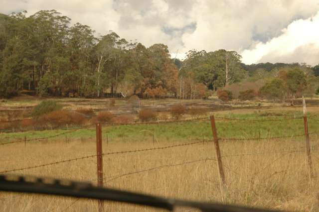
A distant view.
Looking towards the hills of Kangaloon
from the Wingecarribee Swamp area,
below Burrawang Station Lane.
Alan was very keen that I report how impressed he was with the "professionalism" of the RFS people, and their quick response.

Alan is not someone who is given to "false praise". He has some on-going issues with the Council people who have not responded well to his many requests for intervention regarding the Robertson Sewerage Scheme, and the damage done to local properties by Lucas Engineering, and the Council's failure to ensure that simple matters of damage to a local farmer's fences and dams (both of which are vital in the event of a grass fire).

But today he was singing the praises of the volunteers of the RFS. And I agree entirely.

It is Volunteers who are keeping this country running, because Governments by and large have lost control of the myriad of responsibilities they have taken on. So, the local people step in to try and prevent a catastrophe.


Friday, January 18, 2013

Hottest Day Ever, in Robbo

Temperature in Robertson today, was 38.3 C at 13:51 on 18 January 2013.

Well, as records go, this is not statistically "robust". But it has to stand, simply because the Robertson Automatic Weather Station, run from the local Rural Fire Service shed, in Robertson is the only "official" weather station in Robertson, and it has been in operation for about two years only.
However, a record is there, now, until broken in the future.

It certainly was a hot and nasty day.

Fortunately,  a cool change arrived just after 6:00 PM, and it dropped the temperature by more than 15 degrees C.
Wonderful.

My friend Vicki had a snake alarm in the middle of the afternoon. I had been advised by someone, after Matt's encounter with a Copperhead at his front door, that hosing the area where a Snake is known to be hiding will encourage the Snake to move away. In this case I didn't see the Snake, but Owen had used his phone camera to record the colour of the Snake and its dull, slatey colour is typical of a Copperhead. So, I helped hose down the garden bed at Vicki and Owen's front door, and although we did not see a Snake making its escape, I am confident that we would have altered the local environment sufficiently, to make the Snake feel less "at home" than it had been previously.

Vicki then "threw together" a very fine meal, which we all enjoyed. And as I left I realised the longed-for cool change had arrived. Hooray.


Thursday, January 17, 2013

Total Fire Ban in most of NSW tomorrow

http://www.rfs.nsw.gov.au/dsp_content.cfm?cat_id=1109
Check for yourself.

To see the Fire Danger Ratings for your area tomorrow please click on the appropriate area of the map.
 
Click here to view a HTML version of the map.

Glossy Black Cockatoos

Today, much to my surprise, I heard some Glossy Black Cockatoos at Lees Road Lookout (right on the edge of the coastal escarpment - overlooking the Macquarie Pass valley, and Albion Park)

I only heard these birds, and failed to see them.
But I am very familiar with the calls of the Yellow-tailed Black Cockatoos and I know what I heard was definitely not Yellow-tails.

The calls I heard were similar in tone and wheeziness to this recording:
http://www.glossyblack.org.au/audio/Glossy%20Black%20Cockatoo.mp3

Time of the hearing, was approx 4:00PM, January 17, 2013.

I am aware that they are recorded from Kangaroo Valley, where there are suitable stands of "Black Sheoak" Allocasuarina littoralis (along the Bendeela Pondage road - personal sighting).

I have previously reported seeing this rare Black Cockatoo species from the Wollondilly Valley and Nattai Gorge area, off the Wombeyan Caves Road, west from Mittagong. In that case they were feeding on the longer-leaved Casuarina glauca (I think that's the correct species name.)

Dawn's Begonias.

Dawn Wilson (no relation of mine) invited me to call around to photograph some of her Tuberous Begonias. Naturally I was happy to do that, and to post them here for you to enjoy, too,

I shall not bore anyone with the names of any of these plants.
In truth, many are probably hybrids
(seedlings from flowers which Dawn has cross-pollinated herself).
She was doing it today, whenever she found a flower with good pollen.
So these plants are unlikely to be named varieties.

Just enjoy them for the beauty they reveal.
Lovely plants, and relatively easy to grow in Robertson.
 
In Goulburn and more famously in Ballarat, they are grown
in public (Council owned) glasshouses in public parks.


This took my fancy.
A simple flower growing on a tall-growing "cane" Begonia.

a tall-growing "cane" Begonia.


This flower is on a seedling.
As the plant matures, it will probably throw
fully double flowers (like most of these others)


"Begonias are an obvious choice to grow in a semi shaded or shaded area. They are well suited to a wide variety of climates, though excessive cold (eg. frost), direct sunlight or excessive dryness can kill or severely damage most types of begonias. Many will grow well as indoor plants; some are more commonly grown in a shade house or fernery; and others are grown as bedding plants."
Text from "How to grow Begonias" (an Australian website).

I am pleased to see that an old Peony-growing colleague of mine, Martin Farrugia, is still going in the Nursery Industry in Erica, Victoria. These days he is specialising in Begonias and his favourite plant, the Candy Bell (Lapageria). He has good, simple, cultural instructions for tuberous Begonias on his web page.
He starts out saying: "Tuberous Begonias are a cool climate plant, not sub-tropical.
People grow them well in Sydney, Perth and south of these."
"
Choose a place where plants like ferns, fuchsias, hostas or cymbidiums grow.
Give them good light, not direct sun (shade cloth ideal). Not too much wind.
Not indoors – Tuberous Begonias need cool nights."

For more information, visit his website:  http://www.candybell.com.au/begonia_culture.htm

Tuesday, January 08, 2013

More to come, yet..

An RFS interactive Map:

https://maps.google.com.au/maps?f=q&source=embed&hl=en&geocode=&q=http:%2F%2Fwww.rfs.nsw.gov.au%2Ffeeds%2FmajorIncidents.xml&sll=-33.796924,150.922433&sspn=1.739179,2.469177&ie=UTF8&t=m&ll=-32.75825,146.7235&spn=7.2915,13.2388


A Total Fire Ban is in effect for tomorrow as well.
Check out this RFS map.
http://www.rfs.nsw.gov.au/dsp_content.cfm?cat_id=1109
 Area 9: Southern Ranges
.Update- Late night Tuesday * January
Dean Gap Fire - Wandandian
 
The following information has come from the RFS website.
http://www.rfs.nsw.gov.au/dsp_content.cfm?cat_id=684
 
Deans Gap (Wandandian area, south from Nowra)
ALERT LEVEL: Emergency Warning
LOCATION: Fire has reached both sides of the Princes Hwy. Fire is heading towards the Sussex Inlet rd area with 3 strike teams in that area. Significant amount of fire is now burning on East side of Princess hwy through to the 132kv power lines.
COUNCIL AREA: Shoalhaven
STATUS: Out of Control
TYPE: Bush/Scrub fire
FIRE: Yes
SIZE: 1515 ha
 
MAJOR FIRE UPDATE AS AT 8 Jan 2013 22:10: A bush fire  burning approximately 1.5km to the west of Wandandian in the Deans Gap area has burnt through 1,515 hectares. more
RESPONSIBLE AGENCY: Rural Fire Service
UPDATED: 8 Jan 2013 21:52
An emergency warning is in place for the following areas: 
WANDANDIAN, BENDALONG ROAD, BENDALONG, NORTH BENDALONG, CUNJURONG POINT, JANUNG LANE, JERRAWANGALA, SUSSEX INLET ROAD, SUSSEX INLET, CUDMIRRAH, SWANHAVEN, MEDLYN AVE, BERRARA. 

A large bush fire is burning out of control.
The fire is burning in Very High fire danger conditions and is currently between two and six hours from properties.
The fire is currently over 1500ha in size, and has now crossed the Princes Highway. Based on current weather predictions the southerly change is expected to reach the area soon.

The southerly change will cause the fire to head in a northerly direction and impact on Sussex Inlet Road within the next few hours.  It is too late for residents on Sussex Inlet Road to leave the area.

There are a number of firefighters working from the road and conditions are not safe to travel.
Rural Fire Service and Fire Rescue New South Wales firefighters are strategically deployed along the Sussex Inlet Road protecting properties.

The southerly change will bring cooler conditions however, the threat to property will remain.
The Princes Highway remains closed at Bendalong Road in the south and Wandean Road in the north.  It is too late for people to leave the area.

Evacuation Centres are open in Sussex Inlet at the Bowling Club and the RSL. The RSL is capable of taking people with pets while the Bowling Club is not. These centres are open for people who have relocated due to the fire. At this stage there are no evacuation orders in place.

The following roads are also closed:  Braidwood Road, Turpentine Road, Wandean Road and Twelve Mile Road
Advice
  • Do not wait. Act now to protect you and your family.
  • Homes are not designed or constructed to withstand fire in these conditions. Even if your home is specially designed, constructed or modified to withstand a fire and is properly prepared, it may not offer safety from the fire.
  • Protect yourself from the heat of the fire. If you are caught in the path of the fire, you may die or be injured.
  • Updates on this fire, Bush Fire Survival Plans, details of Neighbourhood Safer Places and the latest reports can be found on the NSW RFS webpage www.rfs.nsw.gov.au or by calling call 1800 NSW RFS (1800 679 737).
Further information
  • People are asked not to call ‘000’ to report smoke in the area – please only call ‘000’if you can see a fire without fire fighters in attendance or if your life is directly threatened.
  • For information on road conditions or closures, please call the NSW RTA on 131 700 or check www.rta.nsw.gov.au. Remember roads may be closed without warning.
  • For information on closures of National Parks associated with this fire, please visit www.npws.nsw.gov.au