Christmas Bells

Christmas Bells
Christmas Bells - Blandfordia nobilis
Showing posts with label Nattai. Show all posts

Monday, April 23, 2012

Magnificent Grevillea Garden

On Sunday I had the pleasure of visiting Peter Olde's Grevillea garden at 140 Russell Lane, Oakdale, near Nattai. I went with fellow Orchid enthusiasts and Native plant lovers, Christine, and Ken and Leonie.

The display of plants was remarkable, consisting mostly of Grevilleas, but certainly not exclusively so. There were unusual Hakeas, and Banksias as well as many fine Eucalypts and many, many other unusual Native plants, and even some exotics.

Unfortunately, not many plants were labelled, or readily identifiable (to us) as many were hybrid varieties, it seems. However, a great garden can simply be enjoyed, just like an Art Gallery, by feasting one's eyes on the treasures on display.

One point to note was that native birds were everywhere.
Eastern Spinebill - a nice male bird.
A Red-browed Finch in a Grevillea bush.
There were many Red-browed Finches, Superb Fairy-wrens, and Honeyeaters, of at least 5 species (Eastern Spinebills, Yellow-faced Honeyeaters, Yellow-tufted Honeyeaters, Noisy Miners, and Red Wattlebirds), Magpies, Mudlarks, Kookaburras, Scrubwrens, Willie Wagtails, Grey Fantails, plus some waterbirds on and around the dams. As Ken commented at the time, plant Natives and the birds will come.

A semi-prostrate shrub with great foliage.
A large spreading shrub, this one.

Hakea laurina
A lovely creamy yellow Grevillea

Interesting red Grevillea with greyish ferny foliage
We concluded this beautiful flower is a Hakea,
because of the shape of the seed capsules.

A fine dense Grevillea shrub

Add caption
A lovely golden flowering Grevillea

A bright red Grevillea.
I bought a plant similar to this one.

A stunning citron yellow Grevillea
Another Grevillea with similar colour,
but with extremely good "form"
of horizontally held branches and flowers.
A striking Banksia tree
with interesting foliage and
amazingly long, pointed cones.
Each cone was approximately 15 inches long.


Saturday, December 15, 2007

Wollondilly River Valley - wild, wild country

I wrote about the visit to the Bullio area, and the Wollondilly River, last week, and also in February 2006. For those not familiar with these areas, they are about 40 Km west from Mittagong, along the road to Wombeyan Caves.

On the way back from Bullio I stopped at the Wollondilly Look Out. This is the very southern tip of the Southern Blue Mountains. It is part of the "Nattai Wilderness", itself part of the "Greater Blue Mountains World Heritage Area"As that website describes this region, "The area does not contain mountains in the conventional sense but is described as a deeply incised sandstone plateau rising from less than 100 metres above sea level to 1 300 metres at the highest point. There are basalt outcrops on the higher ridges." You can clearly see the sandstone strata of the entire plateau. What is less apparent is that the very far distant (blue) horizon is the far side of the same plateau (the "Lower Blue Mountains". The bit in the middle has been eroded over millions of years, by the Wollondilly, Nattai, Jamison and Cox's Rivers. If those river names are not familiar, they ought be, for they are the main rivers supplying Lake Burrogorang (the Warragamba Dam), which is out of sight from this position, around the corner past Bonum Pic, and about 30 Km away. It is shown on the map.One can see virtually all the way to Katoomba from here.
The sandstone cliff peak at the centre of the image below, is known as "Bonum Pic". It is slightly lower than Mt Wanganderry, (out of sight to the right) a basalt cap just east from Bonum Pic. The intergrade between the basalt and the sandstone is very marked in this district. This view is of classic sandstone plateaux and valleys, but it is only a few kilometres from Bullio, which is Granite country (as seen in the photos I published a few days ago). The Wollondilly valley has very complex geology. It also has some very determined settlers, if you click on the image above, you will see what I mean. Look for a rough track and houses amongst the trees, way down in the bottom of the valley.

Here is a gentler side to these wonderful mountains: Just past the Wollondilly Lookout, one goes through a "tunnel" - actually a hole cut through a very narrow sandstone ridge. As soon as you go through the tunnel, from east, heading west, you come into a patch of sheltered moist forest (protected from the heat of the northerly sun). There were many of these Blueberry Ash trees in full flower (Elaeocarpus reticulatus)

Monday, August 14, 2006

A View to Forever

Today I went with Beth Boughton to visit Ros Badgery, at her property, Wanganderry, at High Range. What a location!

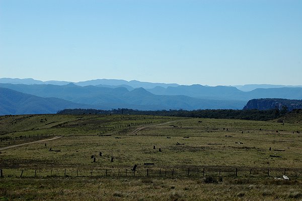
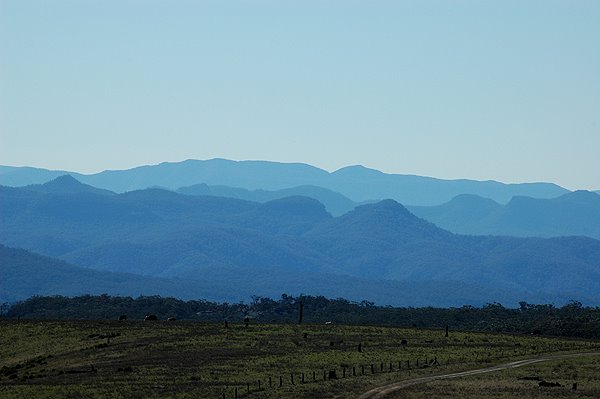
When seen from the southern side, Mt Wanganderry appears as a tiny point, sticking up just a little bit higher than High Range. Yet, it is the highest point in the western side of the Wingecarribee Shire.

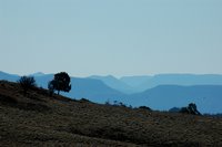
But, as soon as you pass around the edge of Mt Wanganderry, you realise that it deserves its status as a mountain. It forms a clear divide. Beyond Mt Wanganderry, you look north west - "a View to Forever", over a series of valleys, starting with the Wollondilly (coming from the south, and the Nattai, coming from the east).
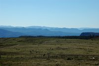
This area is known as the Nattai Wilderness, and is part of the Southern Section of the Greater Blue Mountains World Heritage Area.

This wild landscape spans from here, just a little west of Mittagong, all the way to Katoomba, in the main part of the Blue Mountains.

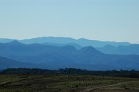
Today was clear, with just a hint of summer haze. But the distinctive blue tinge is real, not "faked up".

I was fascinated by the deeply incised valleys, for although we are looking across to the other side of a vast sandstone plateau, the expected flat-topped profile is far less noticeable than the wildly eroded hills in the middle of the valley.

It is only when you pan around the horizon, that you realise that everything on that vast vista is more-or-less at the same level that the idea of how flat the entire horizon is. Then and only then, does the idea of the vast sandstone plateau make sense.

I hope to paste some of these images together, to give you such a panoramic vista, but that will take me some time.

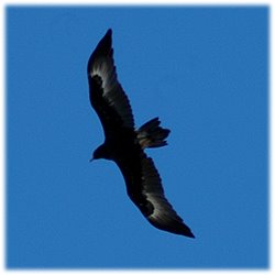
And as we were on the edge of a plateau, with cliffs just a little distance away, of course we were in Eagle territory.


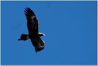
Two Wedge-tailed Eagles were enjoying the late afternoon breezes, as we prepared to leave the Nattai Wilderness.