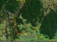
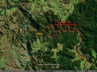
 Local members of the National Parks Association (NPA) led a walk to the confluence of the Wingecarribee River and the Wollondilly River on Wednesday. This river junction is located about 25 Km west of Mittagong, about 5 Kms off the Wombeyan Caves Road. (Two satellite Images are based on Google Earth pictures, with my own additions, labels and coloured lines to indicate the tracks of the 2 rivers in question.)
The NPA had arranged for our group to travel across private property, down a 3 Km long steep and windy track. Eventually we reached the river bottom, and parked on a broad sandy beach, with tall River Sheoaks (Casuarina cunninghamiana). Granite boulders dominated the local river bank. Clearly we were no longer within the sandstone terrain so familiar to residents of the Southern Highlands.
As soon as we got out of the cars, we looked towards the towering hilltops and were rewarded with a wonderful view of no less than 4 Wedge-tailed Eagles (Aquila audax) flying together. They circled, rising and dropping, as they played on the gentle updrafts produced by the light breezes passing across the tops of these mountains.
 Following the very turgid Wollondilly River upstream, we came to the confluence of that river with our own local Wingecarribee River (it rises in Robertson, as the Caalang Creek). Note the extremely rough terrain, and the convoluted path of these 2 rivers, but especially the Wingecarribbee River (marked in red).
I am pleased to report that, compared to the Wollondilly, it was pretty clean. The water had a greenish tinge to it, but it was at least translucent. It was not the pale creamy colour of its fellow river. There were a few large fish visible in the river, (I hope that they were not Carp). There were many small fry in the river, but what species they were, I could not guess.
 After Aunty Val told us her people’s story, we had lunch beside the Wingecarribbee. We were fortunate to have an excellent view of a pair of Azure Kingfishers (Alcedo azurea), (Image: www.dlwc.nsw.gov.au).These birds flew low, just above the river surface (which is very typical behaviour), and then perched, conveniently for us, on low branches of the Sheoaks on the opposite bank of the waterhole.
I was delighted to see these beautiful birds. Not only were they a joy to behold, their presence also indicates that the Wingecarribee River is in pretty good condition.
(Editor's note: I have corrected a previous mis-spelling of the name "Wingecarribee" (not "bb"). Oops! DJW 24.2.06)

No comments:
Post a Comment