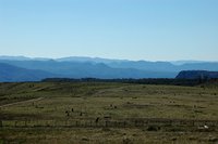
 Today I went with Beth Boughton to visit Ros Badgery, at her property, Wanganderry, at High Range. What a location!
When seen from the southern side, Mt Wanganderry appears as a tiny point, sticking up just a little bit higher than High Range. Yet, it is the highest point in the western side of the Wingecarribee Shire.
But, as soon as you pass around the edge of Mt Wanganderry, you realise that it deserves its status as a mountain. It forms a clear divide. Beyond Mt Wanganderry, you look north west - "a View to Forever", over a series of valleys, starting with the Wollondilly (coming from the south, and the Nattai, coming from the east).
 This area is known as the Nattai Wilderness, and is part of the Southern Section of the Greater Blue Mountains World Heritage Area.
This wild landscape spans from here, just a little west of Mittagong, all the way to Katoomba, in the main part of the Blue Mountains.
 Today was clear, with just a hint of summer haze. But the distinctive blue tinge is real, not "faked up".
I was fascinated by the deeply incised valleys, for although we are looking across to the other side of a vast sandstone plateau, the expected flat-topped profile is far less noticeable than the wildly eroded hills in the middle of the valley.
It is only when you pan around the horizon, that you realise that everything on that vast vista is more-or-less at the same level that the idea of how flat the entire horizon is. Then and only then, does the idea of the vast sandstone plateau make sense.
I hope to paste some of these images together, to give you such a panoramic vista, but that will take me some time.
 And as we were on the edge of a plateau, with cliffs just a little distance away, of course we were in Eagle territory.
 Two Wedge-tailed Eagles were enjoying the late afternoon breezes, as we prepared to leave the Nattai Wilderness.

No comments:
Post a Comment