
This map is an important document, because it shows that contrary to the assurances given to the community, there are three main fault lines (all related), which affect the Kangaloon Aquifer. Fault lines are major cracks in the bedrock (often associated with major uplifts in the underlying sandstone bedrock). These fault lines are relevant to this issue of the Aquifer, because water can flow freely through these fault lines. The fault lines also mean that the shale layer below the basalt is almost certainly ruptured at this point allowing water from the basalt caps to flow through the shale into the sandstone, from where the SCA proposes to drain it from the Kangaloon Aquifer. This gives the lie to the SCA's claim that the water in the basalt caps is separated from the water in the Kangaloon Aquifer.
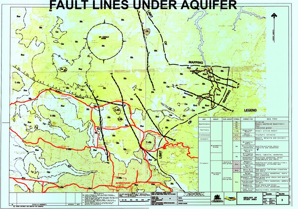
This diagram shows the original map by the NSW Dept of Commerce, published in conjunction with the SCA. The official map title appears to be: "Geology of Study Area".
Its reference number is GL31/A. I have added captions to the map.
The title which I have inscribed on the map "Fault Lines Under Aquifer" is my own title.I have marked in red the main roads in the area, to assist you in following the location of the fault lines. This image has been uploaded as a large file, but it should open in full if you click on the image.
 The first Fault Line is the so-called Mount Murray Monocline. It starts at Mount Murray, and runs through the lower part of East Kangaloon and the Glenquarry area. In fact Tourist Road pretty well runs along the line of the Mount Murray Monocline.
That is not accidental, of course, because the early settlers cleared the good soil areas, primarily, and left the poorer sandstone soils, and when Tourist Road was laid out they more or less followed the edge of the settled farmland. Hence Tourist Road runs along the divide between the rich soil and the poor sandstone soil - which happens to be the Fault Line which is known as the Mount Murray Monocline.
The existence of the Mount Murray Monocline has been well enough known.
*****
What is less well known is that there is a major fault line which runs right from the top of the basalt ridge on which Robertson is located, straight down into the centre of the bore field. Surely water from the basalt springs is susceptible to being drained if the Kangaloon Aquifer is drained? This fault line runs from the top of the ridge east of Kangaloon Road - from the top of the hill, not far past the Hindmarsh Farm. (Sorry, it is west of the road -DJW 16/8/06). It starts where the sign on top of the hill says "East Kangaloon", on your left as you leave Robertson. I published a blog about the springs on this hillside, and the dams in the creek here - two weeks ago. At that time I did not know that this map of the fault lines existed.
The dark line of Sassafras and Blackwood trees, going down the main gully from left, would appear to be following that fault line, according to the map. This is the absolute upper reach of the Nepean River.
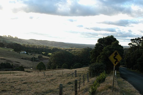 This view, taken from the same place as the preceding photo, looks down, over the Nepean River catchment.
 This fault line appears to run parallel to Kangaloon Road, down into East Kangaloon, through the dense bush patch in East Kangaloon.
If you know where the old dam is located, in East Kangaloon, the Nepean River pretty much follows the fault line, down to Moresby Hill Road, and then through the bush, and across farmland down to where the Nepean River crosses Tourist Road, about 1 Km east of the junction with Kirkland Road.
The main relevance of this is that it means there is a major fault line running directly from the basalt hills of Robertson, down to the most productive bores tested by the SCA last summer, along Tourist Road.
Surely the existence of this fault line calls into question the entire theory that the SCA has been pushing, namely that the springs in the basalt caps of Robertson (and Mount Murray) are protected from the draining of the aquifer. We have been told that there is an impervious layer of shale underneath the basalt, which serves to protect the springs in the basalt from being drained by draining of the aquifer. How can that story be true, when there are major fault lines, associated with significant uplifts of the sandstone bedrock, running beneath the basalt hills of Robertson and Mount Murray?
*****
The third main fault line runs through the cutting below Mount Murray (where the Railway Line and Tourist Road diverge from the Illawarra Highway). From there it runs parallel to Tourist Road (on the western side), past the eastern end of Moresby Hill Road, then through into the wet forest along Tourist Road. The fault line then appears to split. Where Tourist Road curves to the west, the Mount Murray Monocline (fault) is shown as running up the dry sandstone ridge above Butlers Swamp - it then runs all the way through to Glenquarry (parallel to Tourist Road). The other branch of the fault line diverges from Tourist Road in the wettest part of the forest, (below Mount Butler). There is an unmarked creek line there, which runs through the forest into the Burke River (apparently) and on into the Avon Dam.
So, as with the main basalt ridge in Robertson, the eastern edges of the basalt, (from below the Pie Shop), and also Mount Murray, are both directly connected to the bore field by a major fault line. Therefore these areas are threatened by the draining of the Aquifer, in exactly the same way as the basalt ridge behind Robertson is threatened.
No comments:
Post a Comment