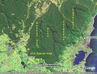
 Here is a "Google Earth" image which shows the Illawarra Plateau. Specifically, it shows four dams on the Illawarra Plateau, north of Robertson, and west of Wollongong. (I have lightened this image, to make it easier to see the details.)
The main area of the Plateau clearly shows up as relatively undisturbed bushland. Some roads (shown by Google as thin yellow lines) circle the main patch of bushland which is known as the "Special Area", which is the protected area, controlled by the Sydney Catchment Authority. Hume Highway runs north from Mittagong. Two roads are shown coming out north and west from Wollongong, crossing the Special Area.
The lake in the bottom right corner, is Lake Illawarra, which is fed by the Macquarie Rivulet, which rises near Mackey's Lane, on the edge of Robertson. The coast, near Wollongong, is just visible.
The Wingecarribee Reservoir (and swamp) is visible in the bottom left. It is fed by Caalang Creek, which rises within Robertson village itself.
Tourist Road is marked - south of the dark green patch of bushland. It winds its way along the edge of the SCA's Special Area.
This image clearly shows the location of the Nepean, Avon, Cordeaux and Cataract Dams, all on the Illawarra Plateau. There is another, smaller dam, the Woronora Dam, which is just out of frame, to the north, also on this plateau.
Although the creeks which feed these four dams start just a few miles from the coast, they lie behind the highest points on the Illawarra Escarpment (Mt Keira, Mt Bulli, etc). The slope backwards, away from the coast, is clearly visible in this image, taken from Stanwell Tops. So, immediately behind the escarpment, these creeks run north and west (away from the coast), until they all join up in the Nepean, above Camden. The Nepean then joins the Hawkesbury, which flows past Penrith and Windsor, then Wiseman's Ferry, and finally heading into Broken Bay, near Gosford.

No comments:
Post a Comment