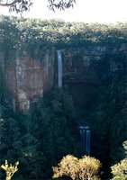
 The best view of Kangaroo Valley which I know of (that is readily accessible) is from Hindmarsh Lookout, which is very close to Belmore Falls.
Click on the photo to enlarge this panoramic image.

Belmore Falls is the closest (to Robertson) of the local waterfalls. It is about 7 Km south of the village, down Belmore Falls Road.
This familiar view shows both the top waterfall (Belmore Falls proper) and a lower level waterfall.
The valley is filled with rainforest trees, and Lyrebirds were clearly heard calling from down in the valley bottom.
I am reliably informed by my bushwalking friends that there is a chain of six waterfalls at stages along the creek. Only the top two falls are visible from this lookout point.
*****
 Near to the Belmore Falls lookout there is a totally different viewing point, right on the tip of the cliffline, where you look directly over Kangaroo Valley township. This is Hindmarsh Lookout.
From that lookout, one first notices the farmed areas in the "Upper Kangaroo Valley" (upper meaning "up-river" from Kangaroo Valley, in that sense). Then in the far end of the valley is the bright green area of the river flats, in Kangarooo Valley itself.
Just past the green paddocks in the bottom of the valley lies the village. The position of the village can be easily made out when the image is enlarged.
In fact the valley down which one is looking is the valley of Barrengarry Creek (which falls over the Belmore Falls). This valley has the same name as the Barrengarry Mountain, down which the main Kangaroo Valley Road passes, when one drives from Fitzroy Falls. However, the place name and this creek valley do not co-incide, as the mountain pass known as "Barrengarry Mountain" (on the main road into Kangaroo Valley) is no less than 2 valleys and 2 ridges away from here. Very confusing.
*****
 I love this peaceful viewing point. On any day, in any weather, at any hour, there is always some point of interest which one can see, or appreciate, at this lookout point.
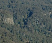
When I was looking at the view from here, I noticed that on the opposite ridge (to the east, i.e., front left, in this view) the cliffline is interrupted in one particular place.
It is places like that which the early European settlers in Kangaroo Valley would seek out, when looking for "passes" where they could develop tracks out of the Valley.
Some of these passes were vital to the economy of the early settlers, for these tracks were how they carried their produce to market, in Sydney, or to the early settlements on the highlands.
 In the middle of this "close-up" image, there is an obvious creek line (with bright, light green coloured trees visible). This "close" may be enlarged by clicking on it.
Just to the right of that creek line, is what looks like a rock fall. That is where it might be possible to find a "pass" up to the plateau above. Almost certainly, this break in the cliff line would have been used as a "pass".
It is at that point where it might be possible to "pass" from the lower part of the valley to the top of the ridge, avoiding the sheer cliffs which otherwise form an impenetrable barrier along the hillsides.
As a matter of interest, the "different coloured trees" are, in fact, Red Cedar Trees, which are deciduous, and this images shows them changing colour, before losing their leaves. Red Cedar was a very important timber tree in the early days of European settlement in Kangaroo Valley.

2 comments:
Wonderful photographs, Denis. Was particularly interested in the Red Cedar trees - so many of them by the colour. When one considers how many forests of red cedar have been destroyed in this country, it was wonderful to see a forest which had a good represenation of them.
Thanks Miss Eagle.
You are right about the destruction of the Red Cedar forests. The Kangaroo Valley largely saw them destroyed too. The small stands of them which survive do so in areas like the one photographed - half-way up a cliff, or in deep, inaccessible valleys. These were places the loggers could not easily drag the logs out from.
Some Red Cedars are better than none.
Post a Comment