This is Wollongong and the Illawarra coastline, as seen from Mt Keira lookout, above the city. Click on that image to see my panorama of this spectacular coastline - perhaps the most dramatic in Australia.
 This fractured coastline is formed by the broken-off edge of the Illawarra Plateau, which is, in effect, a huge sandstone slab which stretches for 40 Kms behind the point of this viewing platform. Indeed it forms part of the huge sandstone formation which includes the Blue Mountains, and the area north of Sydney, nearly as far as Newcastle.
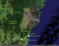
That is the geological formation known as the "Sydney Basin" (see the image of that region - at left - adapted from "Google Earth").
*****
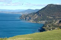
 Here is one of the most popular scenic views of the Illawarra coastline, taken from"Bald Hill", at Stanwell Tops. The view is looking south along the edge of the Illawarra Escarpment, towards Wollongong.
You can see the tiny settlements along the Illawarra Coast. Also visible is the new Sea Cliff Bridge which forms part of the Lawrence Hargrave Drive.
 The dominant peaks seen in the image above all slope upwards on their eastern edge, reflecting the general tilt of the Illawarra Plateau.
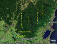
Consequently, the water drainage of the entire Plateau behind Wollongong flows inland from immediately behind these coastal peaks, into the 4 main dams on the Illawarra Plateau (see image at left).
Those coastal clifftop peaks form the boundary of the Sydney Water Catchment.
*****
 Stanwell Park is famous for its historical association with Lawrence Hargrave, who developed and tested his revolutionary Box Kite there. So, this place is important in the history of aviation, for Hargrave's design and plans proved to be of great inspiration to the Wright Brothers.
Hargrave's image and his Box Kite were included in the first Australian $20 note, when decimal currency was introduced to this country in 1966.

No comments:
Post a Comment